Contents of this page:
1. Introduction
2. Transportation modes
3. Evolution of transport
in Switzerland and in the world
4. Mobility an urban form
5. Study in depth
6. References and sources
1. Introduction
"La mobilité est incarnée
depuis 50 ans par l'automobile. Si le cheval est la plus noble conquête
de l'homme, il n'y a pas de doûte que l'homme est la plus
piêtre conquête de l'automobile, qui n'en a fait une
bouchée en un demi-siècle, le plaçant dans
une situation de dépendance chronique. Le plus frustrant
est que l'automobile ne nous a été imposée
ni par Dieu, ni par le diable. Elle est une création technique
humaine, admirable à plus d'un titre, mais hélas non-maîtrisée.
Son développement fulgurant ces cinquante dernières
années nous a totalement fait perdre le contrôle de
notre développement territorial. Nous payons aujourd'hui,
et continuerons de payer demain encore, le prix fort."
Ribi Roland (2005) Introcuction
à Territoire et mobilité, TRACÉS no 13, 2005
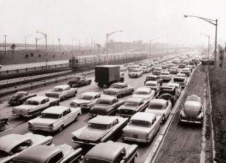
The new expressways were intended to speed traffic in and out of
the city - a train cruises past stopped traffic.
Source: Chicago Transit Authority http://americanhistory.si.edu/onthemove/collection/object_638.html
(08/2005)
Transport results from the spatial
dissociation of dwelling and leisure activities, production and
work places. By accounting for 30% of the energy consumption in
Switzerland, transport is the first source of air pollution and
noise in cities and the main tool of urban spreading.
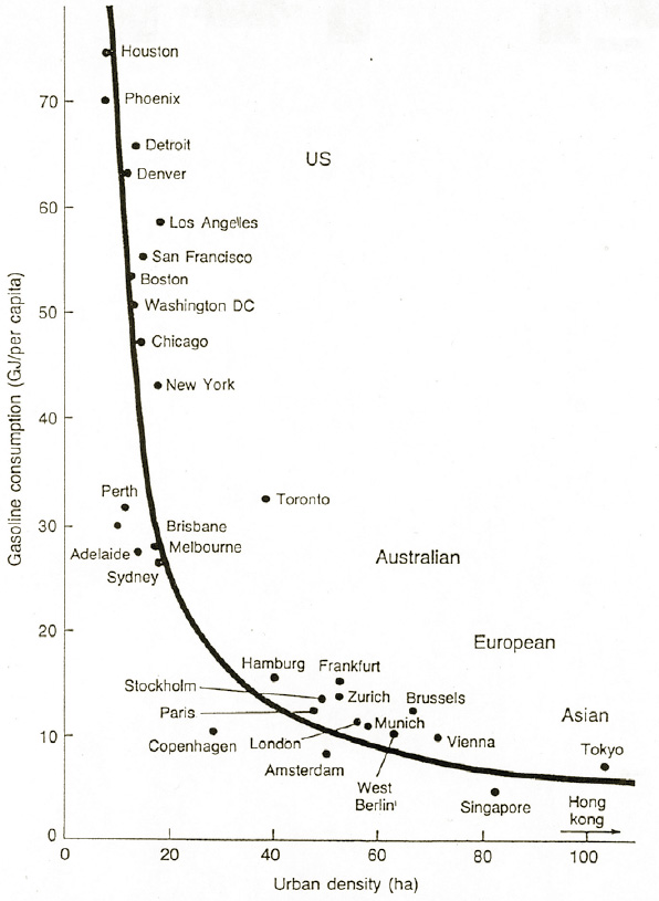
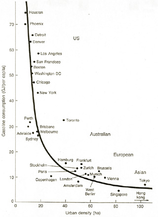
The figure below clearly indicates
the relationship between urban density (inhabitants per ha) and
energy (fuel) consumption. North American cities are among the most
energy intensive while Asian cities are highly energy friendly.
The road traffic infrastructure contributes
to a considerable spreading of the urban areas. This spreading,
that is partly due to attractiveness of countryside dwelling and
lower prices in suburban areas, incites more and more people to
acquire a motorcar. The proliferation of private car ownership,
in turn, leads to even more roads, traffic carousels and parking
spaces. This urban sprawl accelerates in a spiral fashion.
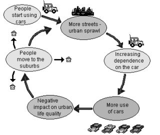
The cycle of urban sprawl
Source: http://www.swedetrack.com/eflwa23.htm
(08/2005)
Land rent relation
Source: [1]
The needs for transport are conditioned
by a variety of vital needs (living, employment, social, cultural...).
Being spatially dissociated, they generate mobility which is the
more significant as the distances are large. By increasing speed,
mechanized means of transport contribute to reduce distances and
make more distant services accessible.
However, this transport has its limits:
on the one hand by the will of the users to devote time and money
to transport, on the other hand because of the saturation of traffic
networks. These constraints, prone to evolution, give the space
limit to urban sprawl. But traffic is only a symptome and one should
rather reconsider the manner of answering the whole of vital needs
on the scale of neighbourhood.
The priority integration of mobility
in town-planning is a fundamental constraint to energy efficiency.
Study in depth >>> http://people.hofstra.edu/geotrans/index.html
Study in depth >>> JACQUES_VICARI_Seminaire_CUEPE_Amenagement_du_territoire_et_énergie.pdf
2. Transportation modes
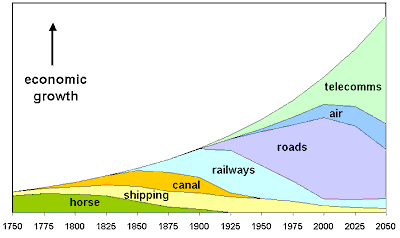
The diagram below - without any great claims to precision - illustrates
the relative contribution of various modes of mobility to economic
growth
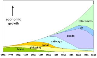
Source: http://www.flexibility.co.uk/issues/transport/time-mobility.htm
(08/2005)
Increases of speed mean that more
journeys can be made in less time. Most importantly, increases in
speed liberate time for other activities. These can be activities
requiring travel, or not. Using the liberated time for value-creating
activity - producing and consuming - fuels economic growth.
However, motorised modes of transport
have failed to reduce travel times in cities; in developed countries,
the distances covered each day by city dwellers have doubled in
the space of 20 years.

Source: [1] Adapted
from Chapman (1989)
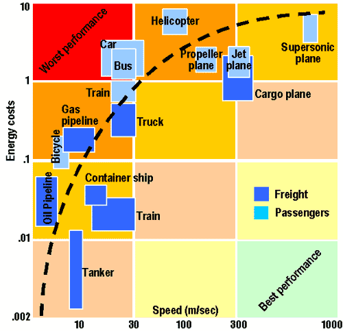
The above brings forward the differences
between speed, energy costs, mode and type of loads (freight and
passengers).
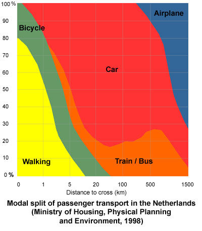
Regional planning conditions the
choice of passenger transport mode, as shown in the fire here below.

Par exemple, on constate sur ce graphique,
valable pour la Hollande, que pour les distances inférieures
à 500 m, 20% des gens se déplacent en vélo,
les autres à pied. Pour des déplacements de plus de
3 km, la majorité des personnes choisissent des modes utilisant
de l’énergie (train, bus, voiture et avion - par opposition
aux SKF, 'Selbst Kraft Fahrzeug').
Source: Ministry of Housing, Physical Planning and Environment,
1998
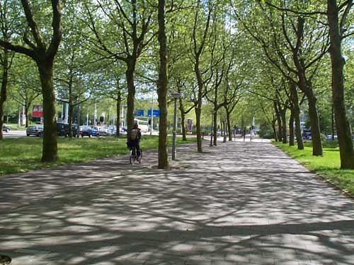
Unmotorized transport
Includes: walking, 'pédibus'
and any kind of vehicle with human propulsion 'HPV' (bicycle, scooter,
rollers, wheelbarrow...)
Like any other mode of mobility,
these means require specific installations to be efficient and to
guarantee safety and complementarity with respect to other modes.
Installations include the possibilities of parking, rest points,
protections (wind, rain, sun...) and infrastructures inside buildings
(lockers, showers).
Green ways are "connecting routes,
which are exclusively reserved to non-motorized traffic and which
improve surrounding areas in respect to quality of environment and
of life in an integrated way. In order to guarantee that they are
user friendly and safe to all different individual abilities of
users, these routes should fulfill a satisfying standard in reference
to their width, slope and surface finish." (explanation of
Lille, 12 September 2000).
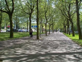
Pedestrian, Cycling and Road Spaces, Amsterdam,
Netherlands
Photo by Dr. Jean-Paul Rodrigue, May 2002
Source: [1]
The Netherlands represents one of the most innovative
and committed country for alternative forms of urban transportation.
These priorities are well represented in the allocation of space
along right of ways devoted to urban circulation. The above photo
depicts a corridor of circulation located just at the outskirts
of Amsterdam's central area. The pedestrian and cycling spaces occupy
as much space as the road and are entirely separated by a linear
greenspace.
Voir aussi :
Vélo, study in depth >>> Guide
à l'usage du gestionnaire d'édifice et de l'employeur
PDF
The space/time map below shows walking time to
5 area schools. Similar maps can be drawn for other services and
other modes.
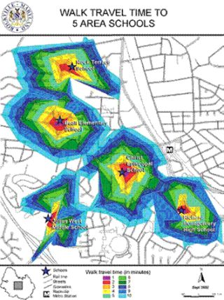
Public transport
Public transport is an energy efficient
alternative to motorized individual transport.
Statements:
Quality public transport allows more
efficient use of a passenger's time.
Public transport, due to its collective
nature, is more socially inclusive than individual transport. The
barriers created by a car-dominated infrastructure, such as urban
freeways or busy highways close to residential areas, isolate communities
and lower the quality of life. Public transport infrastructure,
on the other hand, takes up much less urban space and helps bring
communities together.
Public transport costs the community
less than the automobile once density exceeds 20 inhabitants per
hectare.
However there are still a lot of
improvements to be made, especially in the light of the fact that
time spent on public transport is still perceived by passengers
as lost, particularly during waiting times and at interchanges.
Source: UITP Millennium Cities
Database for Sustainable Transport http://www.uitp.com/
(08/2005)
Individual motorized transport
Motorised modes of transport have
failed to reduce travel times in cities; in developed countries,
the distances covered each day by city dwellers have doubled in
the space of 20 years.
There is a direct correlation between
the numbers of people killed or maimed on the road and the number
of journeys made by a car in a community. Health authorities warn
that breathing in a city may seriously damage your health!
The car in the city - transitory
solutions aiming at optimizing the use of individual vehicles:
- P+R, multi modal transport
- car-sharing
- traffic regulation systems
- intelligent routing (GPS, info highway)
- electric propulsion individual vehicles
Virtual mobility
The convergence of telecommunications
and information technology are creating a new "mode" that
can supplement and replace existing transport modes without the
need to travel. The relationship between virtual mobility and older
forms of physical mobility are complex. The effects of virtual mobility
can be to complement physical transport, or to replace it.
"Virtual mobility"provides
the means to undertake many of the activities that have so far needed
physical transport. But more than this, virtual mobility also opens
up new horizons and new potential for economic activity.
Virtual mobility may stimulate physical
mobility in examples such as:
- work with people on the other side of the globe:
this leads to meetings involving long-distance travel.
- shop online and have goods transported from
far-flung places that probably one would never have visited.
The overall effect on transportation
energy is hard to predict.
Source: http://www.flexibility.co.uk/issues/transport/time-mobility.htm
Multi-modal mobility
Various means of transport prove often complementary.
Cirtical constraints are the management of the 'nodes', total time
devoted to transport and comfort. Psychological factors are also
concerned: for example the latencies between mode changes are generally
perceived like 'wasted' time.
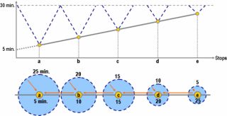
Accessibility along a transit line for
a constant travel time (30')
Source: [1]
3. Evolution of transport in Switzerland
and in the world
The evolution of traffic volume and
mode explain the exponential growth of energy consumption for transport:
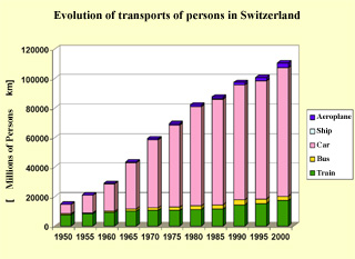
Source: [2]
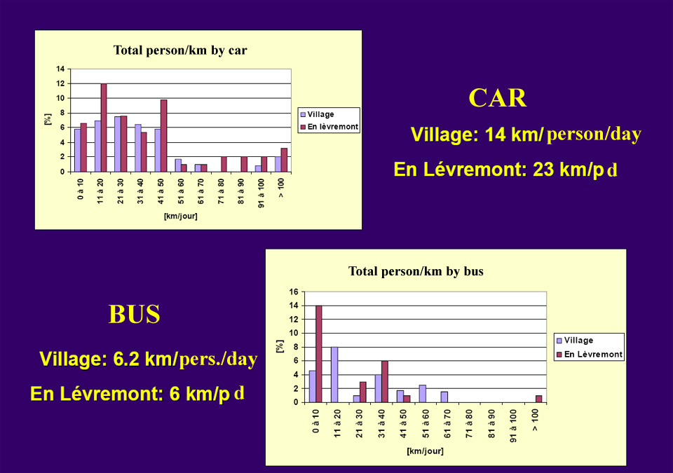
4. Mobility an urban form
Quantity of displacements according
to various urban typologies
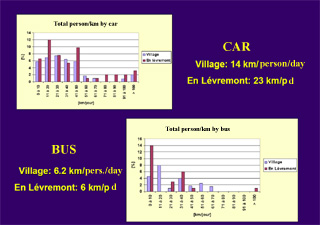
Source: [2]
The compact town / city
Mobility and urban form are closely
related.
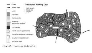
Traditional walking city
Source: [3]
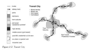
Transit city
Source: [3]
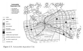
Automobile dependant city
Source: [3]
An aim is the containing of urban
and suburban developments by promoting compactness, functional mix,
pedestrian and slow traffic zones, which contribute to improve the
quality of life in these rather dense districts.
Several axes of planning can be distinguished:
the cross planning of public transport with the living and employment
zones, deployment of collective transport systems (railway) on the
scale of the city, urban desification along the infrastructures
of collective transport, the compact organization of the city (linear,
unipolar or polycentric) which aims at limiting displacements, and
the installation of 'green screens', which channel the urbanization
while rendering ecological and recreational services.
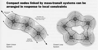
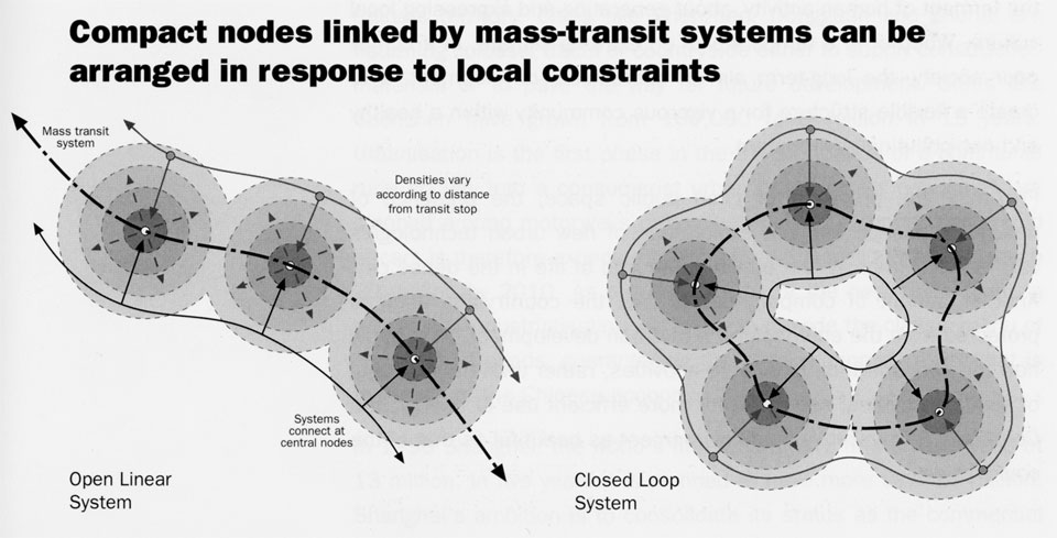
Compact nodes linked by mass-transit systems
can be arranged in response to local constraints
Source: "Cities for a small planet", Richard Rogers, 1997
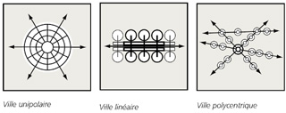
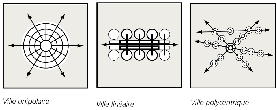
Villes unipolaires, linéaires et
polycentriques
Source: Jean-Bernard Gay
5. Study in depth
JACQUES_VICARI_Seminaire_CUEPE
02_Amenagement_du_territoire_et_énergie.pdf
Transport
Geography on the Web: http://people.hofstra.edu/geotrans/index.html
DEUTSCHLAND_Auto_und_oder_Umwelt_10_gängige_Meinungen.pdf
DEUTSCHLAND_Autoarme_Stadtquartiere.pdf
DEUTSCHLAND_Neue_Mobilitaetskonzepte_in_Deutschland.pdf
DEUTSCHLAND_Siedlungsmodell_Augsburg_Parkierungskonzept.pdf
EUROPE_Brochure_2003_Semaine_europeenne_de_la_mobilite.pdf
HOLLAND_La_politique_ABC_pour_la_mobilite_urbaine.pdf
JEAN_BERNARD_GAY_Seminaire_CUEPE_03_Habitat_infrastructure_et_mobilite.pdf
MONDE_DIPLOMATIQUE_06_05_Ecologie_Le_grand_defi_Index.pdf
MONDE_DIPLOMATIQUE_06_05_Des_choix_qui_engagent_pour_100_ans.pdf
MONDE_DIPLOMATIQUE_06_05_Ravages_et_voracite_du_transport.pdf
TRACES_13_05_Mobilite_urbaine_Index.pdf
TRACES_13_05_De_nouveaux_outils_de_mobilite.pdf
TRACES_13_05_Peages_urbains.pdf
TRACES_13_05_Quelle_mobilite_pour_le_futur.pdf
TRACES_13_05_Territoire_et_mobilite.pdf
WELTWEIT_Mobilitat_2001_ein_Uberblick.pdf
Autres liens intéressants:
>>> http://www.earthscape.org/
>>> http://www.chooseanotherway.com
6. References and sources
[1] Rodrigue, J-P et al. (2005) Transport Geography on the Web,
Hofstra University, Department of Economics & Geography, http://people.hofstra.edu/geotrans
(08/2005)
[2] Gay, J-B (2003) Habitat infrastructure et mobilite, séminaire,
Université de Genève, CUEPE 2003 PDF
[3] Newman, P. and J. Kenworthy (1999) Sustainability and Cities:
Overcoming Automobile Dependence, New York: Island Press.
pg / 22-08-2005
/ mailto |